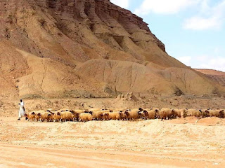
Source Rock for the World's Largest Oil Field


source rock for the world's largest oil field
Add caption


I was browsing and came across this. So I decided to share it to my readers. Happy reading!!!
This outcrop is the geologic type section for the Qusaiba Member, which is a primary source rock for the world's largest oil field (Ghawar). The organic-rich shale of the Lower Silurian Qusaiba Member, of the Qalibah Formation, is one of the most prolific source rocks on the planet. It provides more than 90 percent of the Paleozoic light oil and gas accumulations known on the Arabian Peninsula.


Comments

Popular posts from this blog

Vasquez Rocks

Have you heard of Vasquez Rock? Credit: The above picture will be alien except to those within the vicinity of Aqua Dulce, California or perhaps, those that have visited here at one time or the other. Just watch the arcs and the angles formed by this deposit!! In case you do not know, the image you are seeing is Vasquez Rocks. Am fascinated about the arcs and the acute angles formed by this deposit.. Your groundwater may be polluted!!! Nature is indeed wonderful!!!! For emphasis sake, this is in Aqua Dulce, California, north of Los Angeles. Research has it that the ‘arcs’ formed (i.e. tilting was as a result of the North American Plate collision with the Pacific Plate) along the San Andreas fault. We can see that the collision resulted in the uplift.

CAUSES OF WATER BOREHOLE FAILURES IN NIGERIA

HAVE YOU HEARD ABOUT OIL SHALES BEFORE?? Water is one of the most (if not the most) essential requirements for life existence on earth. It is a well known fact that the human body is made up of about 75% water. Apart from water for drinking, it is relied on for industrial and domestic chores. It is available in the surface and sub-surface. But the surface water is usually not enough and in most cases not available all year round due to seasonal variations namely: Rainy and Dry Seasons . During the Rainy Season, the Surface water becomes readily available (though may or may not be enough depending on the need) but the contrast is the case during Dry Season. Hence the resort to Boreholes . Let’s start by defining a Borehole. In the simplest term, as the name implies: Bore Hole.  It means to ‘ bore a hole’ ; or simply put: ‘to drill a hole’, ‘to sink a hole’, ‘to punch a hole’ on the ground to create a cavity inside the ground where water can accumulate, be sto...

Principles and limitations geophysical method of exploration

Geophysics simply means the application of principles of physics in the study of the earth. The application of geophysics is vast. It can be used to study the entire Earth (Global geophysics), or for localized survey of the crust e.g for Engineering purposes. Geophysical survey is broadly classified into two based on the source of energy. 1.        Natural field: This uses the electric, magnetic,  electromagnetic and gravitational fields of the Earth 2.        Artificial source: Involves the generation of artificial electrical or electromagnetic fields into the earth by a means of a D.C. Magnetic method is applied when searching for buried magnetite ores because of their high magnetic susceptibility. Electrical method is used when exploring for ground water because rocks resistances differ according to their water saturation levels. Seismic method is used for hydrocarbon exploration. It is worth noti...